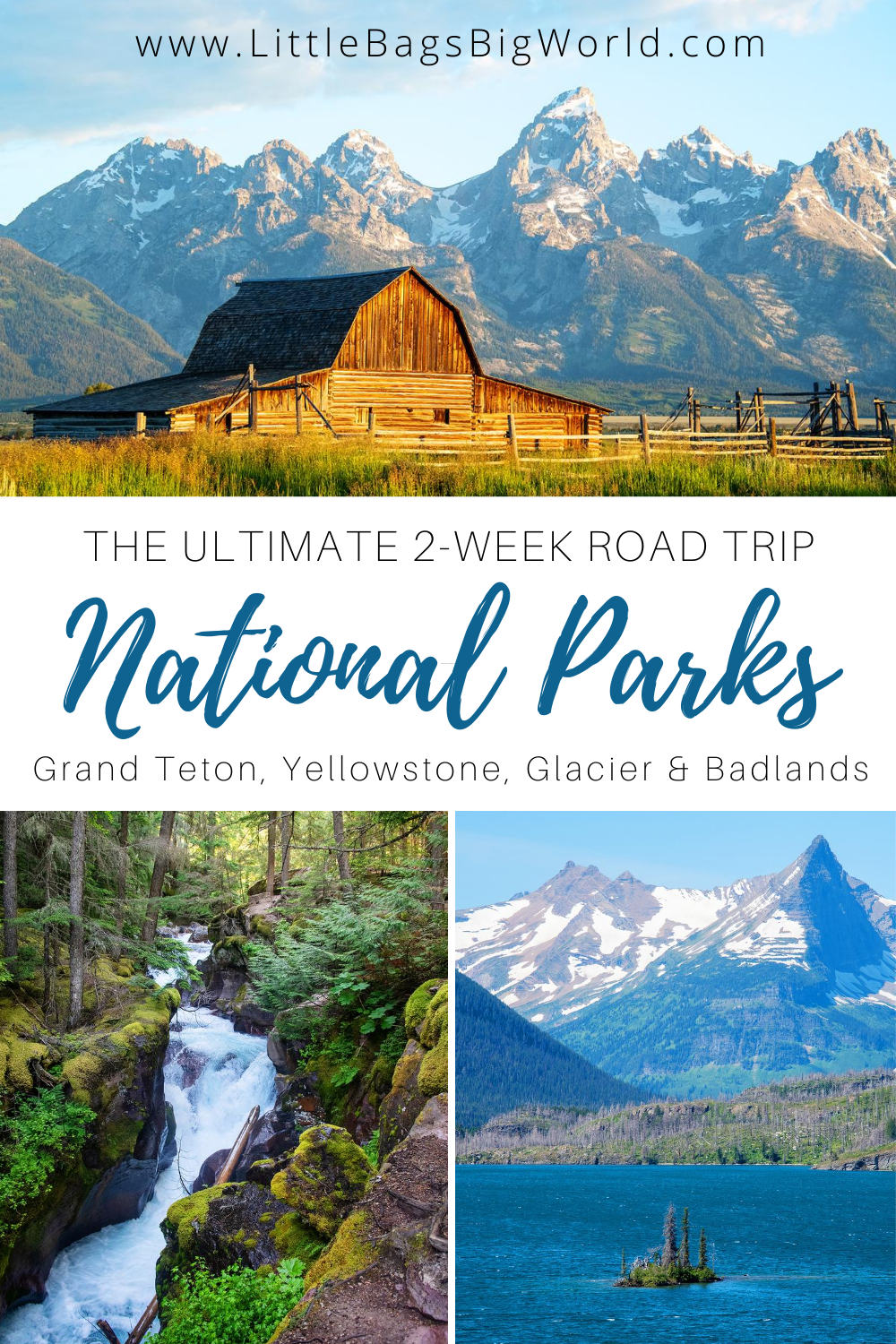
National Park 2-Week Summertime Road Trip


WHO

Our family of four went on this road trip in late July 2020, when Averhy was 16 and Eden was 13 years old. This was a great time to take a road trip to these northern plains and mountain states, because many of the trails don’t open until mid-summer (especially in Glacier National Park).
WHAT
We decided to take a road trip this summer because the COVID-19 outbreak cancelled our original overseas vacation plans. What better way to socially distance by spending time in nature - away from people as much as possible! We used two Motherlode Backpacks and one full-size suitcase for clothing. We ended up purchasing bear spray once we arrived at Glacier National Park (our cabin in the Tetons actually had bear spray we could carry with us on our hikes!) Because we were using our own van for the the entire trip, we could pack some extras (like card games, Sky’s guitar, pillows, and a cooler for food) and these other essentials:
Inflatable kayaks and life jackets
New hiking shoes for Averhy and hiking boots for Eden
Camelbak Helena & Daystar backpacks & water bladders

You will definitely want to buy an Annual National Park pass for this road trip. The $80 pass covers entrance fees at national parks for a driver and all passengers in a personal vehicle at per vehicle fee areas (or up to four adults at sites that charge per person), and it also works at Devil’s Tower and Scott’s Bluff National Monuments. The pass is valid for one year from the end of the month you purchase it - so if you buy a pass on July 1, 2020 it will expire on July 31, 2021. You can purchase the pass online, or at the entrance to most national parks.
WHEN
We took this road trip during the middle two weeks of July. Late July is a great time to visit all of these national parks and sites in the northern Rocky Mountains because the temperatures are still mild - though it was in the upper 90’s for the day we spent in the Badlands! There were some places with snow still on the ground in Glacier National Park, which also led to some closed trails. If we had waited a few weeks later to travel, then those trails might have been open.
WHERE

For this road trip, we slowed down a bit and stayed multiple nights in Grand Teton and Glacier since there is so much to see. These were all good, clean lodging options in great locations:
Budges Slide Lake Cabin #4 (near Grand Tetons)
Absaroka Lodge (near Yellowstone north entrance)
Glacier’s Back Door AirBnB (near Glacier NP)
La Quinta Inn (near Devil’s Tower)
Best Western Plains Motel (near Badlands NP)
The map at the top of this post shows the driving route we took.
WHY
We enjoyed this road trip because most of the drive is filled with beautiful views. Coming from central Illinois (where it’s flat flat flat!) we really enjoyed seeing the change from cornfields to rolling plains to rugged mountains. The drive from Yellowstone National Park to Glacier National Park in Montana is especially pretty. I know that long road trips can be intimidating if you’ve never done one before, but it is doable. We have done multiple long road trips over the years, starting with a 24-hour drive to Arizona when Averhy was 2 years old. The key is to be patient, flexible, and have lots of snacks! I wrote about some of our strategies for traveling with kids in this post. We didn’t do an overnight drive for this trip because we had enough time to break up the long driving days with sightseeing.
HOW

Day 1: Lincoln, NE to Grand Teton National Park
(Day 0 was driving 8 hours from central Illinois to Lincoln, Nebraska). We had about 13.5 hours of driving to do today, so we decided to break it up with a few quick stops at landmarks along the Oregon Trail. The first was Chimney Rock National Historical Site. The visitor center was closed for renovations, but it was nice to stretch our legs.

After Chimney Rock, it was a short 30-minute drive to Scott’s Bluff National Monument. There is a road that leads to a paved path at the top of the bluff, or you can follow the hiking trail to the top if you want to spend more time here. At the base of the bluff, there is a section where you can walk on the original Oregon Trail and learn about the wagon trains.

Another hour and a half further, we stopped in Guernsey WY to see the Oregon Trail Ruts. This National Trail historic site is a section of the Oregon Trail where wagons created ruts in the ground so deep that you can still see them today.
There is a short, paved path to the ruts that is very accessible, with informational signs along the way.
We still had 6 hours to drive to get to our cabin outside the Grand Tetons. We knew that there would be limited grocery store options and no cell service when we arrived, so we stopped in Riverton, WY to load up our cooler with groceries for the week.
We finally arrived at our cabin on Slide Lake at 10pm and got settled in for the week. No complaints about this view and the stars at night were amazing!

Day 2: Grand Teton National Park: Surprise Lake
Grand Teton National Park has a lot of awesome trails and lakes to explore, but the signage at the trailheads is a bit lacking. Be sure to read the maps carefully - our first hike to Surprise Lake turned out to be about 8 miles round-trip and rated “strenuous” (which we didn’t notice before we started!)

The trail begins at the Lupine Meadows Trailhead, and the parking lot was nearly full when we arrived at 11am. The first part of the trail is through forest, then a steady incline through alpine meadows with gorgeous views of the valley. Near the top, the trail gets more rocky and flattens out as you near Surprise Lake. If you want to hike another mile total, you can continue to Amphitheater Lake (which we did not do).
Total hike was 5.5 hours and 8 miles.

Day 3: Grand Teton National Park: Jenny Lake, Hidden Falls, Inspiration Point & Cascade Canyon
The next morning we decided to tackle a few connected trails. The parking lot at Jenny Lake fills up VERY quickly, as do the parking lots at String Lake and Leigh Lake. We lucked out and found a spot at the Jenny Lake overlook on the east edge of the lake at 11am. Our first mile of hiking was all flat and easy.

After crossing the bridge at the String Lake trailhead, it’s another 1.7 miles of fairly easy hiking to get to the west shore boat dock, and then .5 miles to Hidden Falls. The trail from the dock to the falls is more uphill, but still fairly easy.
The view of the falls is worth the hike, which means this area can be crowded.
If you don’t want to hike around Jenny Lake, there is a shuttle boat that goes between the Jenny Lake visitor center and the west boat dock. The cost is $10 adult / $8 child one-way, or $18/$10 round-trip. Due to social distancing guidelines at the time we traveled, they limited the number of people per boat - which meant the line to get on the boat was LONG. (We considered taking the shuttle back to the visitor center after we finished all of our hikes, but we realized the wait would have been over 2 hours… while the hike back would take only 45 minutes. We chose to hike.)

Continuing past Hidden Falls, the hike to Inspiration Point is another 0.5 miles of steep uphill trail and steps. This section is more difficult, but the view at the top is great. We stopped here for a lunch break. It was pretty windy too, so hold on to your hats!
Another 1.5 miles of hiking brought us into Cascade Canyon, with beautiful views and a rushing river in the valley. It was worth the extra hiking.

After Cascade Canyon, we headed back to the dock (where we noticed 2 hour wait for the shuttle boat) so we continued hiking 2.5 miles of the Jenny Trail loop back to the visitor center. The trail was mostly flat and easy. Eden and I took a short detour at the Moose Pond loop trail and saw a moose in the pond! Back at the visitor center, Sky walked the final mile to get our van while the girls and I used the restroom and waited.
Total hiking today was 5.5 hours and 11 miles.

Day 4: Grand Teton National Park: kayaking on Jackson Lake & Bar-T5 Cowboy show
We brought inflatable kayaks with us on this road trip to enjoy the views of the mountains from the water, and this was a perfect day to do that! Jackson Lake is huge, so we decided to put in at Spalding Bay on the south end of the lake. The road to get here is one-lane rough gravel with plenty of potholes, which meant we had the parking area almost completely to ourselves!

Before putting your boat in the water, you need to get it checked near the park entrance and purchase an Aquatic Invasive Species decal and possibly a WY boating permit. Check the National Park Service site for details specific to your boat.
We spent several hours on the water, enjoying the views and even stopping for a few snacks. Another boater let us know that the wind picks up around 1pm, so stay near the shore after that time.

We finished kayaking by 3pm and then headed back for our evening activity - a cowboy dinner and covered wagon ride at Bar-T5 Ranch in Jackson WY!
Although we tend to avoid touristy activities during our trips, this one was fun and entertaining. They did a great job of complying with COVID-19 regulations (masks, social distancing, reduced capacity, and everything was outdoors). We enjoyed the covered wagon ride and the food & musicians were great too!

Day 5: Grand Teton National Park: String Lake & Paintbrush Canyon hikes
After taking a day off of hiking yesterday, we were ready to hit the trails again today! We parked at the String Lake picnic area, which was almost full at 11am on a Wednesday.
Today we combined two trails: String Lake and Paintbrush Canyon. The majority of the trail is through wooded areas, so we kept our hands on our bear spray and called out “hey bear!” as we walked. The trail finally starts to open up once you reach these awesome waterfalls and the path crosses the water several times. There were very few people on this trail - just how we like it!

About a mile past the big waterfall, the canyon opens up into wildflower meadows without much shade. We kept walking another mile to this overlook in the Lower Paintbrush Canyon backcountry camping zone. What a view!
After a snack, we headed back to finish the String Lake loop trail. Total hiking today was 4.5 hours and about 8 miles.

Day 6: Grand Teton National Park: Colter Bay hike & String Lake kayaking
After sleeping in a bit, we drove all the way to the north side of Jackson Lake to check out Colter Bay. This area had a huge parking lot, a boat marina, and camping areas. We walked the 1 mile Lakeshore Trail before driving back to String Lake.

Unfortunately, the parking lots at String Lake were all full by the time we arrived at 1pm. This is a very popular spot for families (both tourists and locals) so arrive early, be patient in the parking lot, and be ready to share the rocky shoreline with others.
We had a great afternoon playing in the water and exploring the lake by kayak. The water in String Lake is so clear and shallow that it looked like our kayak was floating on air!

Day 7: Grand Teton to Yellowstone National Park
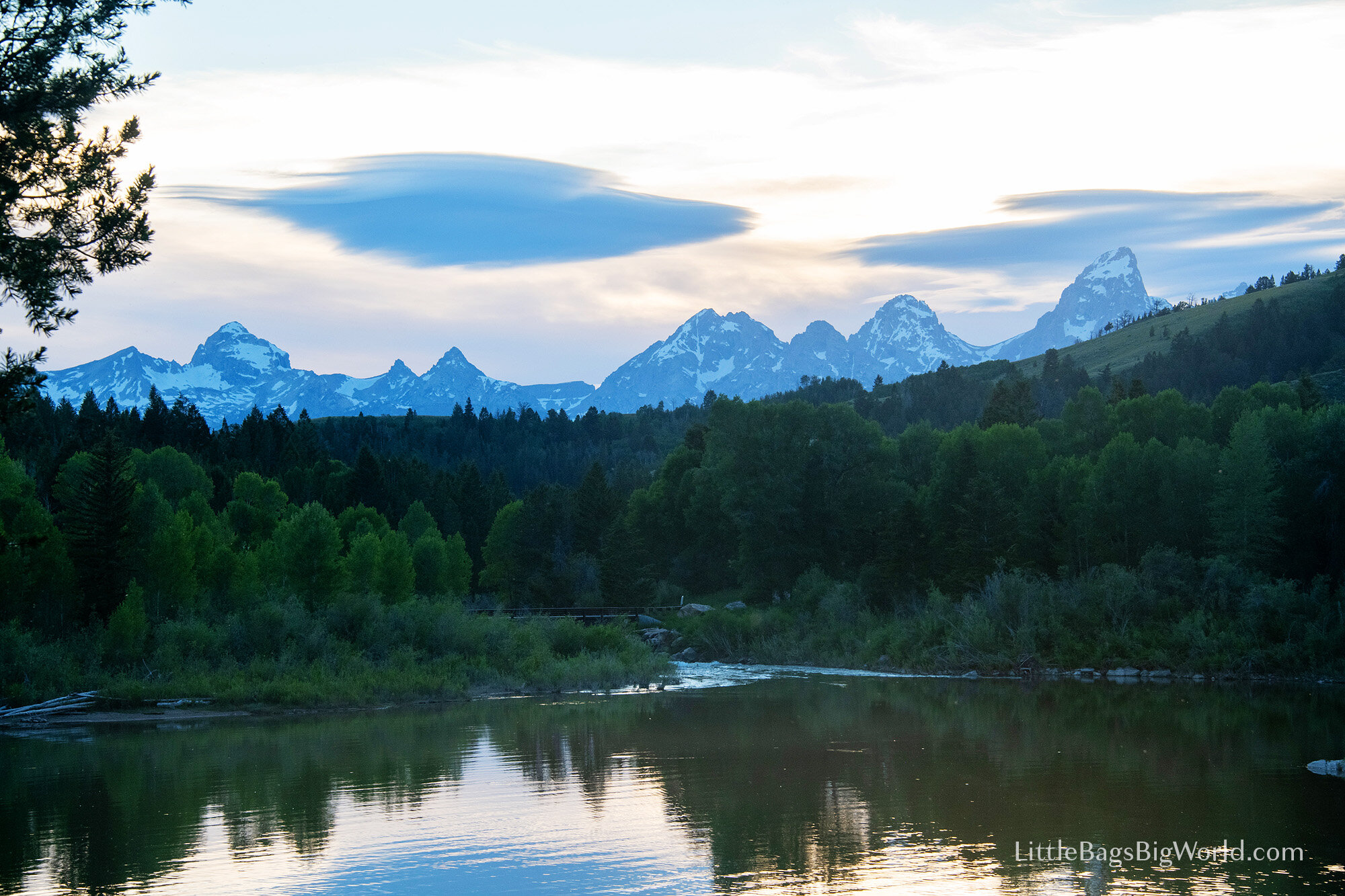
For our last morning in Grand Teton, Sky and I got up at 5:30am to drive and see the iconic Mormon Row barns at sunrise. The weather cooperated and gave us some great views! After packing up the van, it was time to get on the road for our one full day at Yellowstone.

Since we visited Yellowstone a few years ago in the winter, we were able to skip some of the more crowded areas and instead spend time seeing things we hadn’t seen on our last visit here. After a quick stop at Kepler Cascades (with a nice wheelchair accessible overlook) we decided to hike to Mystic Falls. The trailhead is located at the back of Biscuit Basin, after a boardwalk past several hot springs and geysers. This easy trail is about 2.5 miles RT.

Our next stop was at the Fairy Falls trailhead. This parking lot was almost full at 12pm. We hiked to the Grand Prismatic Spring Overlook, which gave us this great view of these colorful hot springs. The trail was busy, but better than the crowded boardwalk that you see in this photo. We continued hiking all the way to Fairy Falls, but this was our least favorite hike of the trip. The forest trail was hot and highly trafficked, and the waterfall at the end - though pretty - was not as impressive as Mystic Falls. Total hike 5mi, 2.5 hours.

Continuing north through the park, we briefly stopped at Gibbon Falls and Virginia Cascades overlooks, and a bison walking in the road slowed down traffic for a bit. Finally we arrived at the Artist Point overlook in the Grand Canyon of Yellowstone.

We spent about an hour enjoying the canyon views, then continued to drive north. Our last stop in the park was at Mammoth Hot Springs. There are several viewing areas at these impressive mineral formations, but the best is on the north side.
We finished our day at Yellowstone around 7pm.

Day 8: Driving to Glacier National Park
Today was a driving day - 7 hours from Yellowstone to Glacier National Park. We didn’t have any sightseeing stops along the way, but the views were beautiful all on their own!
After we arrived at our AirBnB, we drove to the north end of Lake McDonald for a sunset dinner picnic on the rocky shore by the historic Ranger Station.

Day 9: Glacier National Park: Going-to-the-Sun Road & Hidden Lake Overlook Trail
For our first full day at Glacier, we decided to drive the entire Going-to-the-Sun road and stop at any parking lots that had space. This scenic drive is 50 miles one-way, with a speed limit of 25-45 mph, so it’s an all-day affair. After buying bear spray at Glacier Guides, we started the drive at 9am.

We stopped briefly at Sacred Dancing Cascades and then the north edge of Lake McDonald. Continuing north, the parking lots at Avalanche Lake and the Loop were full, so we kept driving and planned to do those hikes earlier in the day later this week.
There are gorgeous views and waterfalls around every turn. The Weeping Wall falls even splash on your car, so roll up your windows!

The highest point of GTTS Road is Logan Pass, and the parking lot was full when we arrived at 10:30am, so we kept driving. We hiked an easy 1 mi trail to Baring Falls before driving on to the Rising Sun Campground. The road was closed past this point, due to COVID-19 closures - but the picnic area was not full at all. We enjoyed lunch on a small beach we had all to ourselves!
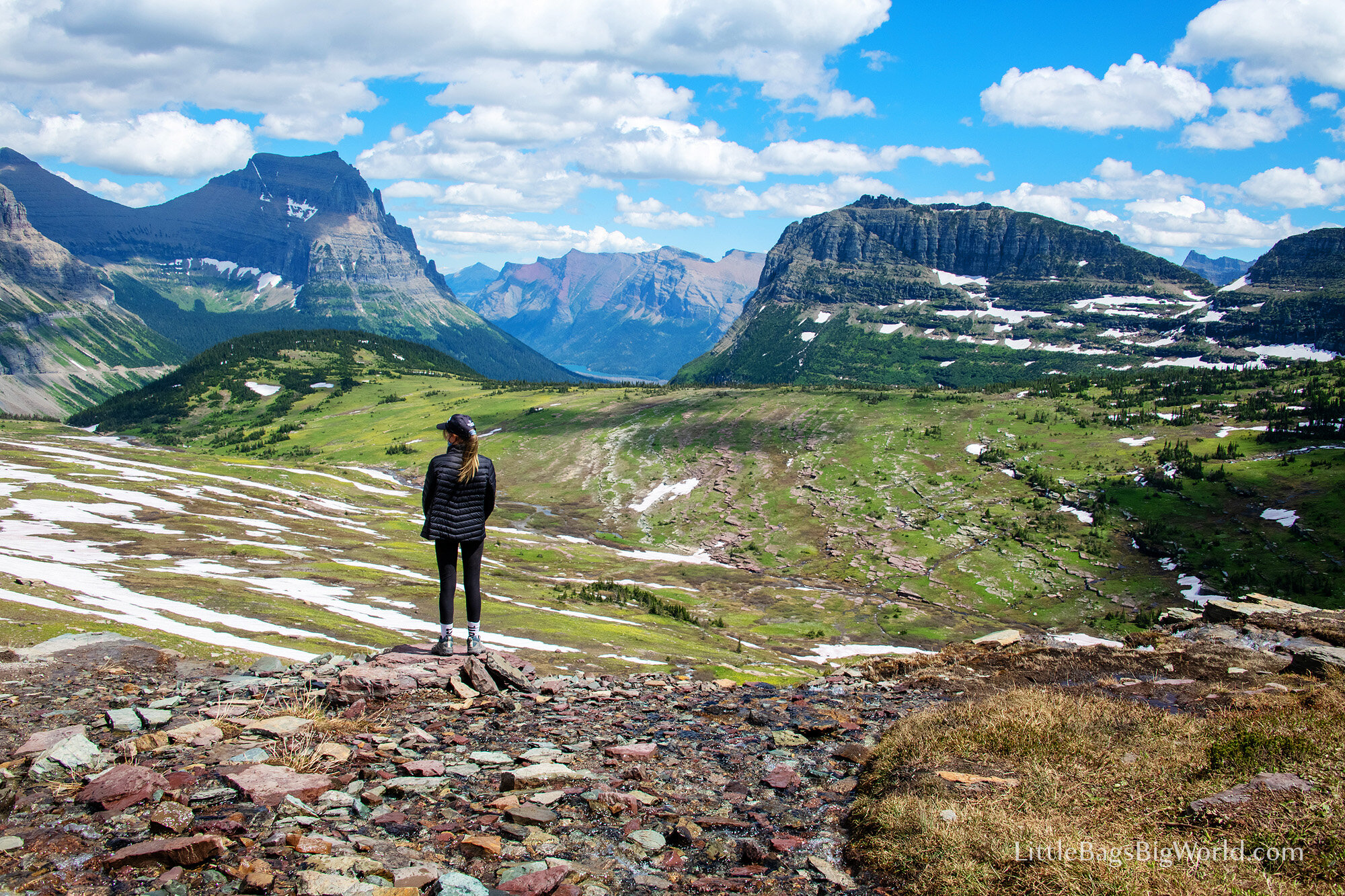
At 12:30pm we headed back toward Logan Pass, and found a parking spot right away at 1:15pm! This is the starting point for several trails, but the trail to Hidden Lake Overlook was the only one open due to bear activity down at the lake and snow blocking the Highline Trail.
This hike ended up being our favorite of the entire trip! It starts with a boardwalk leading to valley views.

The boardwalk ended at a snow field about .5 mile wide, so we were glad to be wearing hiking shoes with great traction. The trail was heavily trafficked because it was the only one open in this area, but the wildlife didn’t seem to mind - we saw 7 mountain goats (including a baby!) and a small herd of bighorn sheep! However, that also means this trail closes frequently due to bear activity. Check the NPS website first…

The view from the Hidden Lake Overlook was amazing! There is a boardwalk and viewing platform, as well as lots of large rocks to the side where you can sit and catch your breath before heading back to the parking lot.
This moderate out-and-back trail is 2.8 miles and took us 2.5 hours - because the girls spent 30 minutes sledding down the snow field at the end!

After we finished playing in the snow, we continued the drive back down GTTS Road, stopping at the Loop parking lot this time for another view of the winding valley. The road heads back down into the valley and follows the river toward Lake McDonald - and we happened to spot this moose crossing the river!

Our last stop was at the Red Rock Point. The water here is so blue against the red rocks, you won’t believe your eyes! There is a small parking area and a newly-renovated path to an overlook, and it’s easy to walk down on the rocks as well to feel the COLD water.
We finished our Going-to-the-Sun Road driving day at 5:30pm - a long, fun day!

Day 10: Glacier National Park: Apgar Bike Trails & Bowman Lake
Today we rented bikes from Glacier Outfitters, located inside the national park. They offer a variety of equipment (bikes, kayaks, etc.) but definitely reserve in advance - we were able to walk right up and get our bikes at 10am, but there were lines of people waiting when we rode by later.

We spent 4.5 hours riding the bike trails around Apgar Village and West Glacier. Bikes are not allowed on hiking trails, and there are not very many bike trails, so we rode them all! We especially liked the West Glacier trail that crossed the Middle Fork Flathead River. There were several people jumping off the bridge into the river, & whitewater rafting groups on the river too. And more amazing blue water!!!

Next we loaded the bikes onto the van and drove 1 hour to the park entrance at Polebridge. From there, the 5 mi. road to Bowman Lake is TERRIBLE and full of potholes, which led to several big dents in the back of our van due to the bike rack bouncing around for the 30 minute drive. Oops! By the time we reached the lake, we only had about 25 minutes to enjoy the lake before heading back to return our bikes. That lake view though…

Day 11: Glacier National Park: Trail of the Cedars, Avalanche Lake, & kayaking on Lake McDonald
Today we got an early start, because we wanted to make sure to get a parking spot at Avalanche Campground - and we snagged one of the last spaces when we arrived at 8:15am. Trail of the Cedars is an easy .8 mile heavily trafficked loop (half of it is a boardwalk) with beautiful Avalanche Gorge waterfall at the halfway point.
The Avalanche Lake Trail continues from this point for another 2.5 miles. This section is less accessible than Trail of the Cedars, but still easy. The path goes through cedar forests and was fairly busy both when we were hiking out around 9am and hiking back at noon.

We arrived at Avalanche Lake at 9:45am and had a quick snack. Then we kept hiking around the right side to reach the far edge of the lake around 10:45am.
There were fewer people on the far side of the lake, and plenty of room to spread out and enjoy the rocky beach. There was an overgrown trail that continued toward the waterfalls, but we didn’t follow it very far because we were concerned about bears.

The Avalanche Lake hike took us just under 5 hours, including an hour of just skipping rocks and relaxing on the beach.
We got our kayaks checked and registered again, then spent the afternoon kayaking on Lake McDonald. This was the only lake within Glacier NP open to boating when we were visiting.
Next, we went home to clean up and have dinner, but most restaurants here are closed on Tuesdays! The only one open was a bar & grill called The Packer’s Roost, so we got burgers to go. (They were delicious!)

Day 12: Driving: West Glacier MT to Gillette WY
After checking out of our AirBnB in the morning, we had a long day of driving to get to our next hotel in Gillette, WY. For the drive home, we decided to break it up into 1 driving day, 1 sightseeing day, and 1 driving day. We did try to stop at the Little Bighorn Memorial, but we arrived just after it closed at 4:30pm.

Day 13: Devil’s Tower National Monument, Crazy Horse Memorial, Sylvan Lake at Custer State Park, Mount Rushmore National Monument & Badlands National Park
Our first stop was Devil’s Tower National Monument. We arrived at 10:30am, just as the parking lot began to fill up. We walked the Tower Trail, an easy 1.3 mile paved loop around the base of the tower.

Averhy twisted her ankle a bit climbing on the boulders, so on to our next stop: the Crazy Horse Memorial. This privately-funded site has an entrance fee of $12pp ($30 per car) and we thought it was worth the cost. There is an impressive museum and visitor center, as well as presentations by local Native Americans that teach about Native traditions and culture. The memorial itself is immense, and we liked learning more of the history behind the sculpture.

Sylvan Lake (within Custer State Park) was our next destination. There is a $20 entrance fee for the state park that allows reentry for 7 days.
We had a picnic lunch on the shore, and then walked half-way around the lake. Boating was not allowed today and several trails were closed due to a nearby forest fire, so we moved on to our next stop.
Wind Cave National Park and Jewel Cave National Monument are also in this area, but they were both closed at the time we drove through - one for elevator repairs, and one due to COVID-19. Check the NPS website to see if they’re open when you want to go!
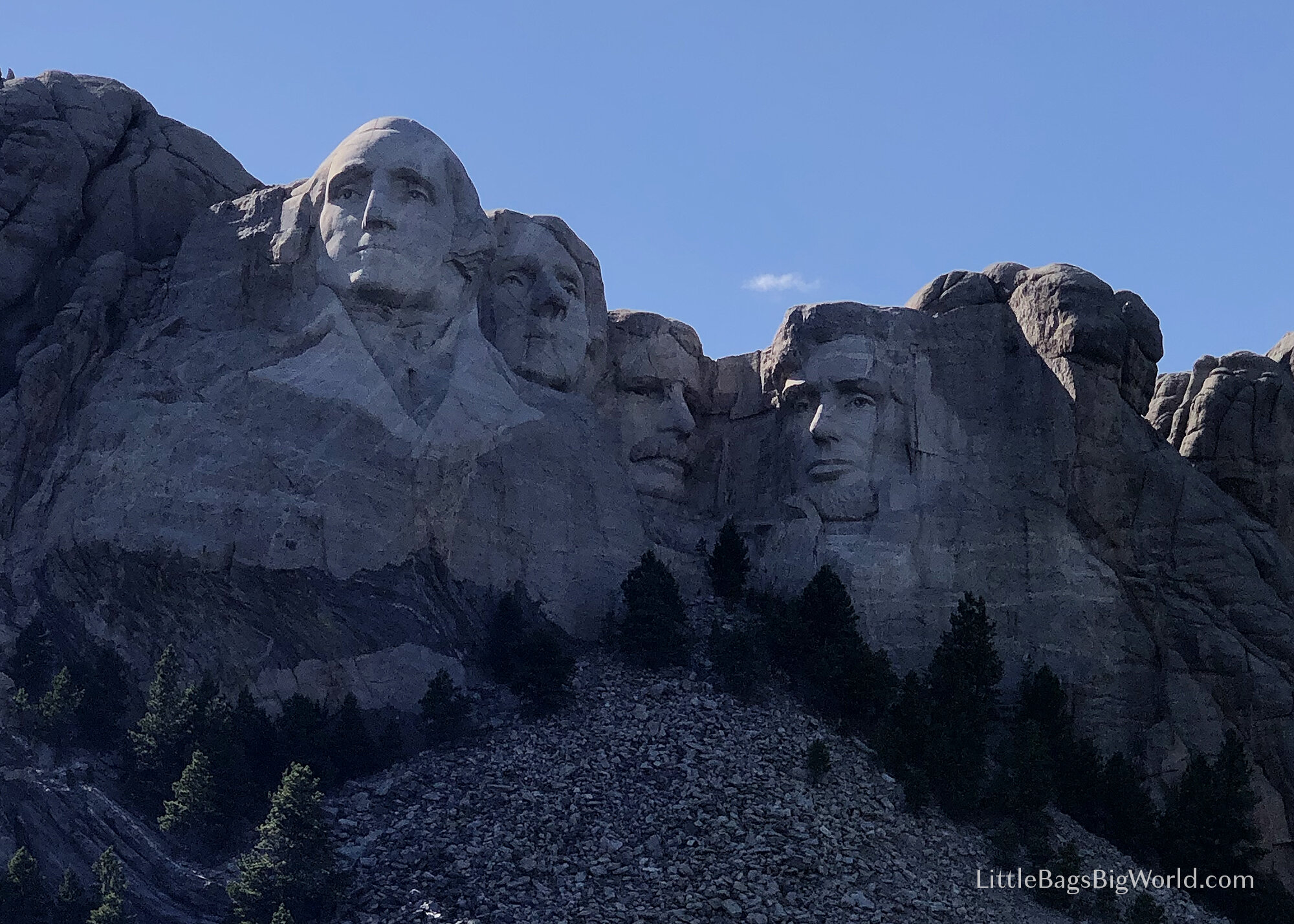
Mount Rushmore has no entrance fee, but there is a $10 parking fee. We found this monument to be less impressive than Crazy Horse, and the super-touristy town of Keystone is one to skip, in my opinion…

After another 1.5 hours of driving, we arrived at the Pinnacles Entrance on the north side of Badlands National Park. Right away we were greeted with views of prairie dogs, bison, and bighorn sheep! We stopped at Prairie Dog Town, Sage Creek Basin overlook, and Pinnacles overlook before sunset.
After dinner, we drove back into the park to enjoy the stars and see the NEOWISE comet!

Day 14: Wall Drug, Badlands National Park, the Mitchell Corn Palace & home!
Wall Drug is a quirky tourist trap, but a fun stop while you’re in the Badlands area. After a quick look around, we drove the Badlands Loop road. It took about 45 minutes to get to the Northeast entrance, due to some construction. There are several easy trails along the way, but we just drove and enjoyed the view from the van because Averhy’s ankle was still bothering her.

After another 3 hours of driving, we stopped at the World’s Only Corn Palace in Mitchell, SD. The exterior of this building is decorated every year with designs made out of corn! Inside, there are displays about the history of the building, and a large auditorium that is used by the community and schools in Mitchell. There is no admission fee, and this was a fun way to break up a long day of driving and wrap up our 2-week road trip! After 10 more hours on the road, we arrived at home sweet home…
Final Tips
Road trips like this one require you to be FLEXIBLE and PATIENT. Everyone gets uncomfortable being stuck in a van after a few hours, so extend some extra grace to yourself and your family. You can read more tips in this post.
Of all the National Parks we visited on this trip, Grand Teton was probably our favorite. There are so many options for adventure: hiking, boating, whitewater rafting, horseback riding, skiing in the winter… and the mountains are just so impressive all on their own!
Be prepared for ZERO cell service in most of Grand Teton and Glacier National Parks. This also means that the “traffic” setting in Google Maps won’t show how busy the parking lots and Going-to-the-Sun Road might be…
What road trip questions do you have? Let me know in the comments below!